It’s been a while since I traipsed across parts of England’s Southwest Coast Path.. I was ecstatic to do a similar walk in Australia.
For a friend’s birthday celebration, we traversed the Coogee-Bondi walk. Well, they say “Bondi to Coogee Walk.” We opted to go the other way around because I wanted to finish off the walk with a swim in the Iceberg Pool. More comfortable to finish the day dripping wet from the pool than to walk in that state, don’t you think?
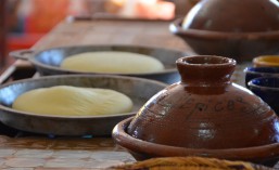
Our first stop was gelato to kick-start the walk. Well, the girlfriends stopped for gelato. I, the lactose intolerant, got to admire some hot beach volleyball players as I waited. Next stop, Giles Baths. The walk is marked by a whole bunch of rock pools/baths, where a natural rock or stony beach is turned into a built-in pool with little effort. Waves supply the sea water. So Giles Baths.. problem:
Yeah. We didn’t think to check the tides.
Moving on.
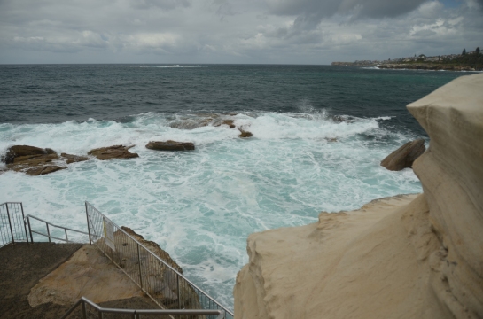
The walk takes us winding through some coves. All of which afforded beautiful views. Path tends to dip down towards the inside of the cove to allow for access to the water and ascend back up the cliffs where the land jutted out towards the ocean.


We got caught in a downpour as we were approaching Clovelly Beach. We tucked under a nearby building’s awning and tried to wait it out. As the rain fell heavier, much to some of our surprise, a bunch of swimmers came out of the woodwork and went right in. Well, if you’re going to be wet anyway.. it wasn’t so much the rain that made us pause. The surf was strong.. the ocean was quite opinionated at the moment. As a swimmer, I was a little jealous of them.. but as someone who is content with my chlorinated box with a blue stripe in the bottom, I admit the waves were intimidating.
Clovelly pool is interesting. The cove is almost perfectly rectangular, because they had poured in straight cement ledges on the long ends, making it into one gigantic ocean pool. I didn’t even see the separate elevated lane pool until later.
We took the longer-than-expected rainfall as a hint. Time to break for lunch.
The sun came out by the time we finished eating and we continued on. We had fun with what we call “Lion King moments.” Some of the jutting cliffs had extended rock formations and we may have been a little silly with our posing.
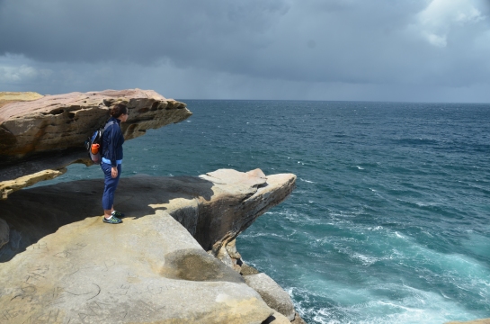
How can you now with a spot like that? No, that wasn’t our “Lion King” pose.. one of the girls just snap-eager while I was making my way out. The wind was no joke, though.. so we were venturing only so far. Side note: I never understood people’s need to leave their mark. Look at the carvings on the stone. It was not a soft stone.. people had to work on those.
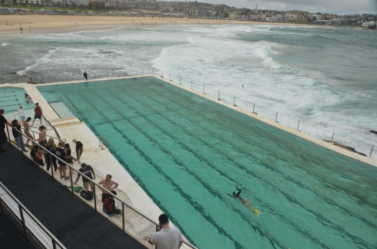
So several of the rock pools were out due to the raging surf (at least for us). But the Iceberg pool was an absolute must for me. I had to go to one.. and the girls were agreeable to chilling out over a pitcher of sangria while I got my over 1500k swim in. I was *not* prepared for how cold the water was. The waves were lower by the time I went in, but I still felt the swaying. Actually, I felt it more when I got out, with land sickness and swaying as I walked. It took only a few minutes to recover, but I was gripping onto walls and surfaces. An unexpected pleasant perk in swimming here? Being surrounded by equally serious swimmers. I’m used to being the swimming in a recreational pool. This is a swimmers’ pool.
One con? They nickel and dime you out to go to this pool. Admission, I understand. Towel? $2. Lockers? Another $2.
Total Tally:
– Weather: Occasional gusty winds, alternating between bright sun and heavy down pour. Drizzly more than not.
– End points:
33°55’08.4″S 151°15’30.8″E
33°53’41.9″S 151°16’27.4″E
– Path conditions: mostly varying concrete pathways, some dirt path
Highlights: Beautiful views, rock pools, and an amazing swim to finish the day off.


